

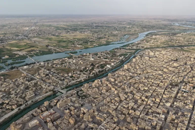
An Unseen Event for Syrians in Decades: What Are the Reasons Behind the Sudden Flooding of the Euphrates?
SadaNews - After years of forced drought and a sharp decline in water levels affecting the Euphrates River, the lifeline of eastern Syria is overflowing once more, marking an unprecedented historical event since 1988. The spillway gates at the Euphrates Dam have begun to open in succession as the reservoir nears full capacity.
This scene, absent from the eyes of Syrians for nearly 36 years, not only reflects a sudden change in the water reality of the region but also places the technical administration of the dam in a crucial position to manage this unexpected water abundance. So, what are the reasons for the rising water levels and how did the authorities respond?
Why Did the Euphrates Reservoir Suddenly Fill Up?
The sight of water flowing through the gates of the Euphrates Dam was no coincidence; it resulted from a combination of exceptional climatic and geographical factors witnessed in the river basin during the current season after many years of sharp decline.
In this context, dam and water resources expert Abdul Razaq Al Aliwy clarifies the numerical dimensions of this abundance to "Syria Now," stating: "As a result of the abundant rains that fell this year, the Euphrates Dam's reservoir received approximately 5 billion cubic meters of water, pushing storage to 97% of the reservoir's maximum capacity in the river."
Al Aliwy adds that this near-complete fill placed the General Authority of the Euphrates Dam before an urgent technical choice, which manifested in raising the water release rate to exceed the normal planned volume of 290 cubic meters per second. The current water flow has reached 800 cubic meters per second, with projections of a critical threshold at 1000 cubic meters per second, which explains the opening of 3 spillway gates to control this unusual flood wave.
The Euphrates Dam - also known as the Tabqa Dam - is located on the Euphrates River in the town of Tabqa, about 50 kilometers west of Raqqa. It is 4.5 kilometers long, 20 meters wide at the top, and 60 meters wide at the base.
The dam body is made of cement and steel, designed to withstand earthquakes up to 7 degrees on the Richter scale, while it retains behind it a reservoir with a capacity exceeding 10 billion cubic meters of water.
Emergency Preparations and Precautionary Measures
As the spillway gates opened and the water level of the Euphrates River rose, some crops in agricultural lands in the Al-Buhamid area east of Raqqa were already affected. The relevant authorities and emergency services took a series of urgent measures to protect the residents, crops, and facilities along the river course.
The Early Warning and Preparedness Directorate at the Ministry of Emergency and Disaster Management issued strict instructions to residents along the riverbanks or within its vicinity in Raqqa and Deir ez-Zor, including preparations for flooding at water levels exceeding two meters and the immediate evacuation of homes and businesses near the river, especially in low-lying areas.
In addition, navigation with boats and water ferries was halted, crossing through dirt bridges was minimized, and it was advised to refrain from using them altogether if the water level rose further. Swimming was completely banned, and families, livestock, machinery, and agricultural equipment were to be moved to safe, higher areas, according to the Syrian news agency (SANA).
Agriculturally, Ali Al-Aloush, director of agriculture in Deir ez-Zor province, confirmed that the directorate took measures to protect the agricultural and animal sectors against any potential further rise in water levels. This included clearing and opening agricultural drains immediately in low-lying areas, reinforcing dirt embankments near the banks and areas adjacent to river islands, hastening the harvest of ready wheat and barley crops before they are submerged, and temporarily halting irrigation to avoid soil saturation and the collapse of dirt bridges, according to SANA.
Additionally, monitoring the water level every 3 to 6 hours in low-lying villages was implemented, sandbags were prepared around at-risk areas, alternative routes were identified for tractor and truck movements, livestock were to be moved to higher areas, feed was to be stored on wooden or concrete platforms, clean water tanks were secured in anticipation of contamination, and periodic veterinary campaigns were conducted to mitigate diseases related to humidity and stagnant water. Seed, fertilizer, fuel, and machinery were transferred to safe locations, electricity was cut off from pumps and wells near flooding areas, and sandbags were used to protect barns and warehouses, as well as lifting generators, engines, and tanks.
Regarding infrastructure and traffic in Raqqa province, traffic was temporarily suspended on the temporary bridge (connecting the Al-Karama area with Ma’dan across the Euphrates banks) as a precautionary measure due to the emergence of holes and cracks in the previously filled section due to the impact of rising waters, pending completion of technical inspections and repairs.
The authorities announced its temporary closure yesterday, and SANA reported the head of the Roads Department in the Technical Services Directorate of Raqqa, engineer Ahmad Al-Dandal, stating that crews had begun procedures that included cutting the bridge and temporarily removing arches to facilitate the entry of 20 cement trucks towards the southern end of the Al-Rashid (new) bridge for completion of the pouring, along with sending a heavy crane to lower concrete blocks to reinforce the damaged section of the old bridge for safety, confirming that the structural situation was under control.
The Euphrates Between Its Historical Course and Accumulated Crises
The exceptional significance of the Euphrates Reservoir's sudden filling cannot be understood without considering the complex historical and environmental background that this water artery has experienced, which represents the primary source of freshwater in Syria, historically meeting about 85% of the water needs of the agricultural sector, in addition to being fundamentally relied on as a source of drinking water and livestock raising.
The river has suffered from structural and historical challenges over the past decades that have significantly affected it, as temperatures in northeastern Syria have risen by one degree Celsius and rainfall rates have dropped by 18 millimeters per month in the century.
This climate change has led to a reduction in the flow of the Euphrates and Tigris river system to nearly half the annual average during drought years, prompting regional entities such as the Iraqi Ministry of Water Resources to previously warn of the river's drying danger by 2040, as agricultural yields, such as wheat, have declined by up to 75% since 2011.
Years of prolonged conflict and the pressures of war have also caused a 40% decline in drinking water supplies in Syria due to the severe damage inflicted on vital water and electrical infrastructure and the division of major dams among different controlling areas.
This institutional weakness has meant that many plans and laws remained ink on paper, such as the Ministry of Housing and Construction's plan to address water pollution from industrial and domestic waste, and laws to update irrigation systems and impose fees, forcing about 47% of the population to rely on unsafe alternatives for water transport, historically resulting in the spread of epidemics such as cholera due to stagnant water and low water levels.
Although the 1987 agreement signed between Damascus and Ankara set the minimum water flow at the Syrian-Turkish border at 500 cubic meters per second, the river has witnessed a sharp decline in flows in recent years, dropping to around 200 cubic meters per second only.
Source: Al Jazeera + Syrian Press
 Follow the latest Sada News via Google News
After Deschamps' Departure... Zinedine Zidane Tops the Candidates to Lead France

Mbappe Surpasses Messi and Becomes the All-Time Top Scorer in the World Cup

England Defeats France and Achieves Largest World Cup Achievement Since 1966

Messi Refused to Play for Spain and Missed 3 World Cups

Publishers Sue Google for Allegedly Using Books to Train Artificial Intelligence

Google Expands Capabilities of Google Search Console to Support Social Media Accounts

The Mediterranean Table... An Ancient Diet Revealing Its New Secrets for Health and Longev...
