Analysis Reveals: The Occupation Army Identifies Dangerous Areas as Shelters for Displaced Persons from Gaza City
SadaNews - In light of the recent statements by the spokesperson for the Israeli occupation army, Aviv Kohavi, who confirmed that "the evacuation of Gaza City is inevitable," alarming details are emerging about the operational planning that is supposed to direct the movement of displaced residents of Gaza Strip according to the occupation army, raising growing concerns of an imminent humanitarian disaster.
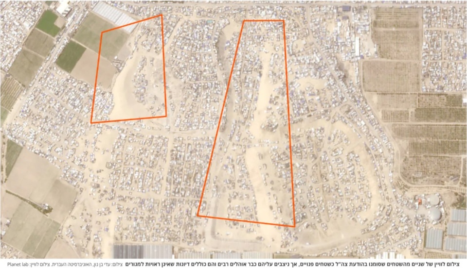
The newspaper "Haaretz" published an investigation based on an analysis conducted by mapping experts "Adi Ben Nun" from the Hebrew University and Professor "Yaakov Garb" from Ben-Gurion University, revealing that several areas announced by the Israeli occupation army as designated for the displacement of residents of northern Gaza Strip are, in fact, areas that the army has classified as "dangerous" and unfit for civilian habitation.
Ironically, the map published by the occupation army highlights these areas in red, reflecting a stark contradiction between official Israeli statements and the operational reality.
The analysis conducted by the Israeli professor Garb showed that this issue is not limited to one or two cases, but rather that among the 19 "blocks" of displacement identified by the occupation army, there are 6 blocks that are partially or entirely located outside the permitted areas.
The problem does not stop at the contradiction in defining the areas but extends to the nature of these areas themselves. According to the analysis, the available area for displacement does not exceed 7 square kilometers, which is a very small area compared to the number of people being asked to evacuate. Worse still, this area is not entirely empty, as some of it consists of lands unsuitable for setting up tents, while other areas already contain established tents, limiting the capacity to accommodate more displaced persons.
Recent satellite images sent by Ben Nun and Garb to "Haaretz" showed that some areas appear as sand dunes, which are likely impossible or very difficult to set up tents on or live in under reasonable conditions. Meanwhile, other places appeared as roads or areas that could be flooded by rainwater, complicating the situation further and reducing the viability of these areas as temporary shelters.
In this context, humanitarian organizations operating in the sector warned that any new evacuation process would lead to a humanitarian catastrophe, especially since most residents have already been displaced multiple times, suffering from harsh living conditions, and lack the physical or psychological capacity to be displaced again. These organizations emphasize that the humanitarian situation in Gaza has reached critical levels even before discussing a new evacuation, making any step of this nature fraught with risks.
Kohavi's statements, in which he described the evacuation as "inevitable," reflect an official inclination towards executing a large-scale operation, despite the growing warnings about its humanitarian and logistical consequences. While military officials discuss the necessity of evacuation, on-the-ground realities reveal a lack of realistic planning, conflicting information, and a lack of fundamental elements that ensure the safety of civilians.

SadaNews Clarifies the Truth About a Report Attributed to the Washington Institute Regardi...

Head of Gaza Administration Committee: Rafah crossing will open next week "in both directi...

Britain Reveals Its Position on the 'Council of Peace'

Trump Signs Founding Charter of the "Peace Council" in Davos

Settlers Storm the Tarseleh Evacuated Site South of Jenin

Election Commission: 12,400 New Citizens Registered in the Voter Registry

American Report: The Palestinian Authority Is Out of the Stability Equation

