Occupation Approves 3 Major Plans to Expand "Ma'ale Adumim" Settlement
SadaNews - The Wall and Settlement Resistance Commission revealed that the occupation authorities have approved three major plans concerning the "Ma'ale Adumim" settlement built on citizens' lands east of occupied Jerusalem.
The head of the commission, Minister Muayyad Shaaban, stated that the recently approved major plans aim to create a geographical connection between the settlement and the "Mishor Adumim" industrial area, further isolating more geographical areas between the two settlement sites.
Shaaban added that these plans were submitted for approval in late 2024 and are currently being approved, reflecting a clear intention in a race against time to impose facts on the ground, especially in the vicinity of the holy city of Jerusalem, which exacerbates the process of isolating and besieging it through various colonial measures targeting it.
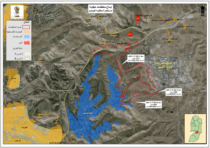
He noted that upon reviewing the maps and documents attached to these plans, it became clear that the three plans, marked in red on the attached map, integrate to create a geographical connection between the "Ma'ale Adumim" settlement and the "Mishor Adumim" industrial area to the east of the settlement, indicated in yellow on the map.

Shaaban mentioned that the three plans are as follows: First, the structural plan numbered יוש/ 1/ 59/ 7/ 1/ 420 for the benefit of the "Ma'ale Adumim" settlement, aiming to build a total of 1113 new settlement units on an area estimated at 1307 dunams of citizens' lands. The second plan, numbered יוש/ 2/ 59/ 7/ 1/ 420, aims to build 944 settlement units on an area estimated at 680 dunams, which integrates with the first plan. The third plan aims to build 1108 new settlement units on an area estimated at 486 dunams, which combines with the previous two plans to create a geographical connection between the "Ma'ale Adumim" and "Mishor Adumim" settlements built on citizens' lands between the Jerusalem and Jericho and the Jordan Valley governorates.
He clarified that the mentioned plans include building a new settlement neighborhood, in addition to a new road network that strengthens the grip on the main street, isolating the gatherings of Bir Al-Maskoub, Sanisil, and other gatherings from those located to the west of the settlement and from the street altogether, as illustrated in the map.
Shaaban added that during the entire year of 2024, the occupation submitted 21 structural plans concerning settlements outside the boundaries of the Jerusalem municipality, while in the first half of 2025, a total of 28 structural plans were submitted for the same geographical area, as part of the significant, intense, and unprecedented targeting of this area.
ــــ

High-level sources reveal to SadaNews: Washington seeks to hold a Gaza Reconstruction Conf...

Race for Influence in Gaza Reconstruction: American Companies and Officials Compete for Bi...

Ahmad Al-Ahmad.. Unarmed Australian Muslim Confronts Perpetrator of Bondi Beach Attack in...

سفير أميركا لدى تل أبيب يجري زيارة إلى قرية الطيبة بعد ساعات من تأييده إقامة 19 مستوطنة با...

Leader of an Armed Gang in Gaza Appeals to the World to Unite Gangs under a Security Appar...

Yedioth Ahronoth: America Requested Israel to Take Responsibility for Removing the Rubble...

From Areas Controlled by Israel in Gaza.. Anti-Hamas Groups Seek a Permanent Role

