

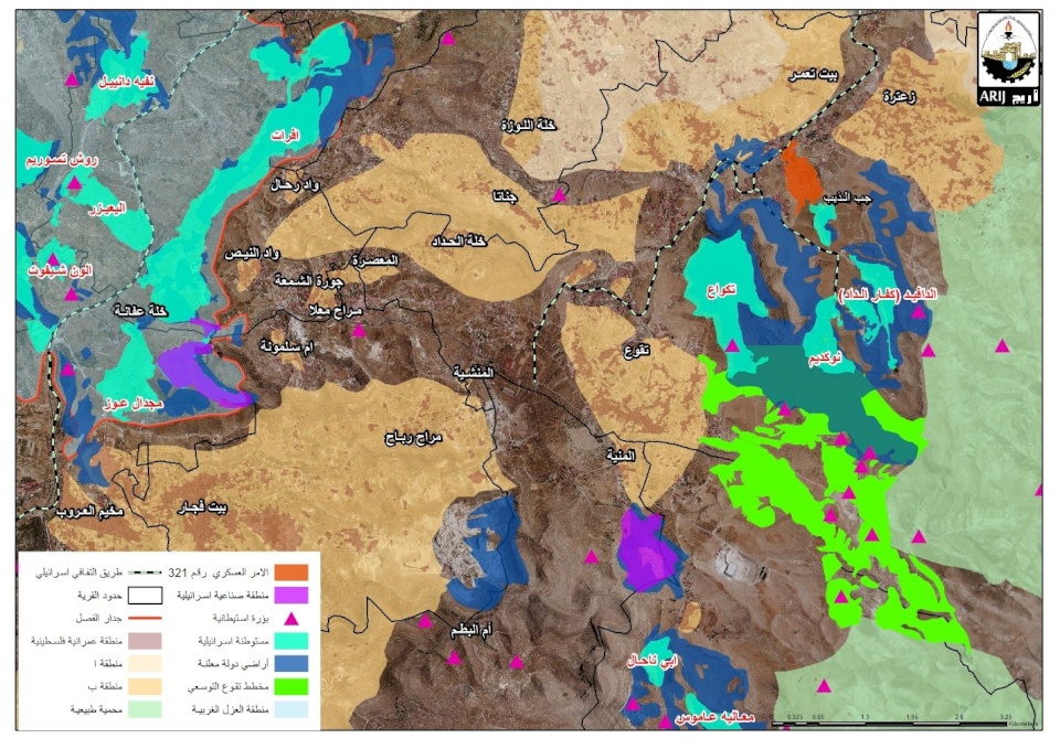
Expansionist Colonial Scheme to Seize Thousands of Dunams Southeast of Bethlehem
SadaNews - The Applied Research Institute "ARIJ" - Jerusalem, announced today, Thursday, that the Israeli occupation authorities approved the seizure of 6,000 dunams, as part of a large-scale colonial structural plan for the area located southeast of the settlement of Tekoa, built on the lands of the town of Tekoa in Bethlehem.
The institute stated in a statement that the so-called "Regional Council of Gush Etzion Settlements" in the southern West Bank approved on July 20 this month a colonial structural plan that extends over an area of approximately 6,000 dunams, which is being promoted in collaboration between the "Gush Etzion Regional Council", the "Tekoa Settlement", and the colonial "Amanah Movement".
It pointed out that the new colonial plan includes the establishment of residential colonial units, tourism facilities, operational areas, agricultural lands, in addition to open spaces, and roads in the area that lies between the villages of Tekoa and Al-Maniah, and the lands that have been classified as a natural reserve east of Bethlehem.
It explained that the occupation authorities aim to create a geographical extension of the Tekoa settlement towards the south by seizing Palestinian lands, and colonial construction therein, which will limit Palestinian urban expansion in the area.
The institute clarified that this colonial extension will work to create significant geographical connectivity between settlements and Israeli colonial outposts in the area, such as Ma'aleh Amos, Abi Hnahal, and the settlements: Tekoa, Nikkudim, and David, thus forming a colonial belt in the region, but under the umbrella of the so-called "Gush Etzion Regional Council".
The institute noted that the expansionist colonial plan for the "Tekoa" settlement was published by the head of the so-called "Gush Etzion Regional Council" Aron Rosenthal.
It affirmed that this colonial plan, according to what Rosenthal stated, is "a strategic step aimed at enhancing the development of the eastern part of Gush Etzion and ensuring the future of Jewish communities in the area".
The institute clarified that the head of the colonial council said in his statement on social media, "We are not only looking at the next few years, but we are planning for the future of the coming generations, and we will continue to build, develop, enhance colonialism, preserve the land, and create a colonial connectivity that ensures the continued growth of Gush Etzion".
The institute said: An analysis of the plan and the image published by Rosenthal showed that part of the targeted area, amounting to 28.2%, which is 1,640 dunams of the total area of the plan of 5,822 dunams, falls within the lands classified by the occupation authorities as "government lands" due to Israeli military order number 59 of 1967.
It added that the new colonial plan reveals that the seizure of Palestinian lands is no longer limited to what the occupation authorities claim to be "government lands", or "settlement influence areas" or other Israeli classifications, but extends to include Palestinian lands that fall outside these classifications, thus surpassing various classifications used by the occupation authorities themselves, indicating that they seek to impose a new colonial reality, regardless of the classifications they rely on to justify their expansionist colonial policies in the occupied Palestinian territories.
 Follow the latest Sada News via Google News
Expansionist Colonial Scheme to Seize Thousands of Dunams Southeast of Bethlehem

Katz Threatens Iran and Israel Awaits Trump's Green Light

UN: Food Security Improved in Gaza but Remains Fragile

3 Martyrs in the West Bank Since Morning

The Central Committee of Fatah Discusses the Palestinian Situation and Assigns Leaders New...

Mossad: Foiling an Iranian Attempt to Recruit Foreign Agents for Assassinations in Israel

Injury of a Soldier.. Occupation Talks About Killing a Young Man Who Carried Out First Sta...
