Weakness of "Flying Rivers" in the Amazon Leads to Increased Drought
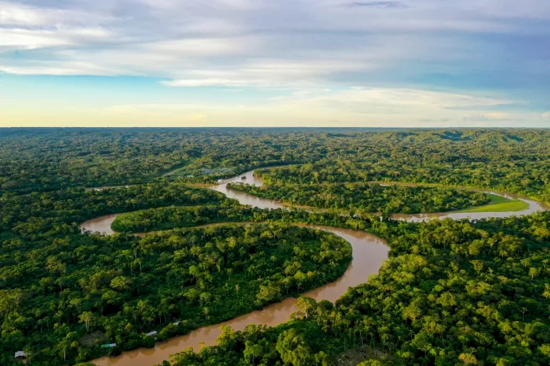
SadaNews - Drought has caused crops to wither in Peru, fires have consumed the Amazon forests, and hydroelectric dams in Ecuador are struggling to maintain electricity with dry rivers. Scientists say the cause may lie in the upper rainforests, where invisible "flying rivers" carry rain from the Atlantic Ocean across South America.
A new analysis warns that ongoing deforestation disrupts the flow of water, indicating that continued loss of trees will exacerbate drought in southwestern Amazon, potentially leading those areas to transform from rainforest to drier savanna, meaning they will become grasslands containing far fewer trees.
Matt Finer, a senior researcher in the Andes Forest Monitoring Project of Amazon Conservation, which co-authored the analysis, states, "These are the forces that create and sustain the Amazon rainforest. If you damage this pump by cutting too much forest, rain will stop reaching the places it needs to go."
What are Flying Rivers?
Flying rivers are broad air currents that carry vast amounts of water vapor through the atmosphere. Most of the Amazon's rainfall falls over the Atlantic Ocean, and moist air is pushed inland by steady winds blowing west along the equator, known as trade winds. At that point, the forest acts as a pump, effectively transporting water thousands of miles west as trees absorb it and then release it back into the air.
Brazilian climate scientist Carlos Nobre was among the first researchers to calculate the amount of water vapor coming from the Atlantic that travels through and beyond the Amazon basin.
He and his colleagues coined the term "flying rivers" at a scientific meeting in 2006, and interest in the topic has grown as scientists warn that weakened rivers may push the Amazon toward a tipping point where the rainforest could turn into savanna.
The Amazon, with its approximately 400 billion trees, is a massive storehouse of carbon dioxide that significantly contributes to global warming. This transformation could devastate wildlife and indigenous communities, threatening agriculture, water supplies, and weather stability in areas far beyond the region.
Serious Warning Signs
The analysis found that southern Peru and northern Bolivia are particularly at risk. During the dry season, rivers flow through southern Brazil before reaching the Andes mountains, where deforestation peaks.
Tree loss leads to decreased water vapor transported westward, increasing the risk of drought in iconic protected areas like Manu National Park in Peru.
Finer stated, "Peru can do everything it can to protect a place like Manu, but if water resources in Brazil continue to be drained, the necessary rain may never arrive."
Nobre adds that up to 50% of the rainfall in western Amazon near the Andes depends on the flying rivers.
Corinne Frizendorf, director of science at the Amazon Conservation Organization based in Cusco, Peru, states that the past two years have been the driest ever in the Amazon region.
She notes that "the environmental calendars used by indigenous communities, farming dates, fishing, and animal breeding have become increasingly out of sync, which will affect their lives more than climate change is already doing."
Researchers found that rainfall patterns depend on the timing and location of flying rivers passing through the basin. During the rainy season, its northern path predominantly flows over pristine forests in Guyana, Suriname, and northern Brazil, maintaining the system's strength.
However, during the dry season, when forests are already under heat stress, the flying rivers cut through southern Brazil, where deforestation fronts spread along highways and farms, reducing the number of trees that help transport moisture.
Finer says, "During the dry months, when the forest is in desperate need of water, the flying rivers are subject to the most disruption."
Discussion of the Tipping Point
For years, scientists have warned about the Amazon rainforest's tendency toward savanna. Finer states, "It's not a single collapse at once; some areas, like southwestern Amazon, are more vulnerable and will be the first to be affected, and we are already seeing early signs of reduced rainfall downwind in deforested areas."
Nobre notes that the risks are severe, as the Amazon has already lost about 17% of its cover, most of it due to deforestation for cattle ranching and soybean farming, which recycle much less water than these ecosystems should.
He points out that the dry season is now five weeks longer than it was 45 years ago, with a 20 to 30% decrease in rainfall; if deforestation exceeds 20 to 25%, and temperatures reach two degrees Celsius, there will be no way to prevent the Amazon from reaching a point of no return."
Researchers say that protecting intact forests, supporting indigenous land rights, and restoring deforested areas are the clearest paths forward in restoring the balance of the Amazon forests and their vital role in regulating the planet's climate.

Soaring Oil Prices Burn the Pockets of the Palestinian Citizen "The Poor"

Millions of Dollars in Losses.. "SadaNews" Reveals Shocking Figures for Traders from Pales...

The Problem of Shekel Overcrowding Worsens.. Fuel Station Owners Threatened with Closure o...

High-level sources reveal to SadaNews: Washington seeks to hold a Gaza Reconstruction Conf...

The Palestinian Economy at a Crossroads: 4 Files Awaiting Resolution

Smotrich: Israel Has No Interest in Joining the War Against Iran

Occupation Issues Military Order to Seize 5 Dunams of Land in Jaba'
