Wall and Settlement Resistance Authority: The occupation is indeed starting to convert a small outpost into a large settlement southeast of Jerusalem
SadaNews - The head of the Wall and Settlement Resistance Authority, Minister Moyad Shaban, stated that the occupation authorities have published a new plan to alter the boundaries of the "blue line" concerning the "Mishmar Yoshida" outpost southeast of the holy city of Jerusalem. This step is considered a dangerous settlement expansion targeting the lands of citizens in the governorate and consolidates the policy of creeping annexation imposed by force on the land.
Shaban explained that the reviews of the Wall and Settlement Resistance Authority indicate that the occupation authorities have approved the transformation of the Mishmar Yoshida outpost into a settlement in 2023 following the formation of the extreme right-wing government. The recent decision by the blue line team today outlines the boundaries of the new settlement, showing the intention of the occupation state to establish a large settlement containing thousands of settlement units, which is an addition to the steps racing against time to change the features of Palestinian geography and subjugate it to the apartheid and colonial settlement system.
He added: The authority's documents reveal that the "Mishmar Yoshida" outpost was included in the list of 11 outposts that the occupation government approved to convert into settlements in February 2023, including the Malachi Hashalom outpost (designating 745 dunums of state land for it), Avigal and Asa'il (land allocation orders were issued concerning them), Givat Harel and Givat Haroeh (a decision was made to merge them, mentioned in the last announcement of 19 settlements), Beit Hogleh (a structural plan was recently proposed for it), in addition to the outposts of Sidi Boaz and Shaharit. This announcement comes as an insistence from the occupation state to transform these outposts into settlements that enjoy all privileges at the expense of Palestinian lands.
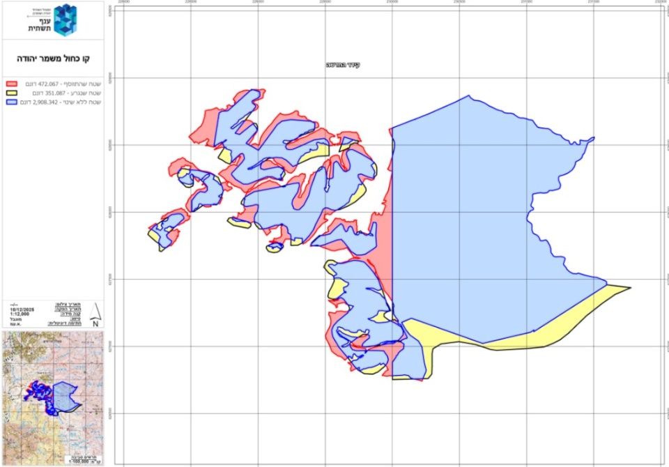
The official documents released by the occupying army on 18/12/2025 clearly indicate the occupation adding about 472 dunams to the settlement's control area, in contrast to excluding 351.08 dunams, while maintaining a total of 2908 dunams unchanged from the initial declaration that was issued on October 1, 1982, by which hundreds of dunams were declared as government land from the lands of Abu Dis and Su'warah towns south of Jerusalem.
However, this new amendment intensifies the separation between the holy city of Jerusalem and the southern governorates of the West Bank by positioning a new settlement on the line of the Maale Adumim-Kedar settlements to the south of the governorate, as stated by the authority.
Since the 1990s, the occupation authorities have created what is known as the blue line team, which is affiliated with the occupation's civil administration and is responsible for land setting and construction in the Palestinian territories currently under Israeli occupation. The naming of this team as "the blue line team" is due to the fact that the boundaries of the maps produced by this committee, which indicate lands declared as state land, are colored blue.
Under the pretext of establishing this team or committee, when the occupation state declared vast areas of Palestinian land as state land, preventing Palestinians from developing or using them, and confiscating them, it claimed to lack technological capabilities and advanced maps. However, since the 1990s, it has asserted that it has established this committee to review previous declarations and return lands to their rightful owners while, of course, confiscating new lands.
The work of the blue line team is limited to redefining Palestinian lands that have been confiscated in the past by declaring them state lands under the pretext of ceasing cultivation for a period or due to their roughness and non-arability. Some of these lands have been allocated by the occupation authorities for the establishment of settlements, and with the expansion of settlements, many of these settlements have extended beyond their existing organizational plans and even outside what is known as the settlement's area of influence and reached private Palestinian lands outside the settlement's jurisdiction.
The danger of this redefinition or study of the borders of land declared as state land lies in the fact that no one has the right to challenge it in Israeli courts. Although the declarations issued by the Israeli occupation allow for a right to objection within a period of up to 45 days, the experience of Palestinians in this context, derived from the common denominator of the results of the blue line team's survey, indicates, as shown in the maps, that the total area declared in the old announcement remains almost the same, or with limited relative difference. However, the most dangerous aspect is that new areas of strategic importance for the future expansion of settlements are being incorporated into the new mapping, while similarly sized areas in terms of dunams are being excluded.

Sheikh Offers Condolences for the Martyrdom of Citizens in Deir Jareer

Ministry of Labor Calls for Registration in Licensed Private Vocational Training Centers a...

Occupation Forces Storm the Home of Major General Bilal Al-Natsheh in Jerusalem

The Working Group on Palestine of the Permanent Independent Human Rights Commission Issues...

Arrests in Occupation Attacks in the West Bank and Jerusalem

Ramallah and Al-Bireh Forces Mourn Al-Mughayer Martyr and Emphasize Popular Solidarity to...

More than 38,000 travelers crossed through the Karama crossing last week
